Introduction to QGIS Symbology
- Time13.00 - 16.00 CET (UTC+1)
- Duration2 sessioner (4 t)
- Price1850 dkk - €250 excl. VAT
- PlaceOnline
- TeacherKurt Menke
Course content
This short course teaches you everything needed to master the basics of symbology and labeling in QGIS. You begin by learning the basics of point, line, polygon and raster symbology. After this introduction, learn to create Graduated renderings (choropleth maps) and Categorical renderings of your data. Along the way, learn to use and interpret data histograms, use different classification modes and quickly make changes to symbols via master symbol settings.
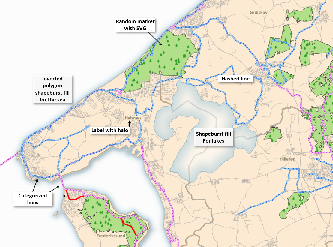
You will then be introduced to Symbol Layer Types and learn to create more complex symbols with stacked symbol layers. For example, you will learn some use use cases for Inverted Polygon Shapeburst Fills.
You will also learn basic labeling and how to use labelling expressions and settings.
The course concludes with use of the Symbol Manager to save, import/export and manage styles. If you want to master basic symbology in QGIS, this course is for you.
In the course you will be learning about:
- Using the Layer Styling Panel
- Basic styling for points, lines and polygon data
- Categorical and Graduated Rendering
- Classification modes
- Equal count
- Equal interval
- Jenks Natural breaks
- Use of Histograms
- Using the Master symbol button
- Classification modes
- Labeling
- Configuring labels
- Fonts & text formatting
- Automatic placement
- Halos
- Backgrounds
- Label callouts
- Custom placement
- Labeling expressions
- Configuring labels
- Styling Raster data
- Styling terrain data
- Hillshade
- Contours
- Styling categorical rasters
- Styling terrain data
- Introduction to Symbol layer types
- Using SVG icons
- Creating Hashed lines
- Creating Line pattern fills
- Creating stacked symbols
- Using Inverted polygons
- Configuring Shapeburst fills
- Point pattern and Random marker fills
- Raster marker symbols
- Using the QGIS Syle Manger
- Saving symbols
- Tagging symbols
- Importing / Exporting symbols
Course format
The course consists of:
- An introductory video
- One class sessions - 3 hours
- An assignment
- One question/answer sessions with the opportunity to ask questions about each task
Course price
1850DKK - €250 excluding VAT
Introductory video: One week before the course starts you will receive an introductory video with an introduction to working with symbology in QGIS.
Course sessions: During the live course session the course instructor (Kurt Menke) will introduce a series of symbology and labeling techniques.
Assignments: To support learning, after the course session you will be asked to complete an assignment taking approximately 1-2 hours.
Question/answer sessions: This will be held one week after the course session. During this session you can ask questions about the assignment.
Additionally, you will receive a brief manual and a series of short videos covering topics presented in the course sessions.
Course dates
- Course Session: Monday 18 September from 13.00 - 16.00 (CET)
- Question/answer session: Monday 25 September from 14.00 - 15.00 (CET)
QGIS certified course
The course is certified by the QGIS organization, which has approved the material and the course program. When you participate in this course, you contribute 20 euros to the continued development of QGIS. You will also receive an official certificate after participating in the course.
Practical information
The course is held in English.
QGIS 3.28 is used for the course. You must ensure that you have access to a computer with this version of QGIS (or later version of QGIS) installed before the course. QGIS with either the Danish or English translation can be used.
Register before: 11 September 2023.
Contact Kurt kurt@septima.dk, if you want to hear more about the course, or want to register.